- 3/26/2021 Latest edits added Geocolor spectrums for all the regional satellites.
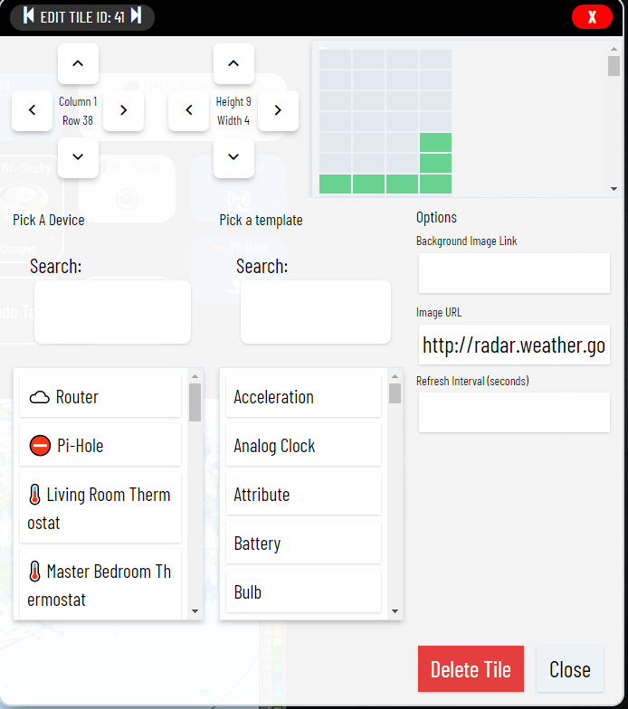
If you want a weather radar map from the National Weather Service for your area you can add an image tile to any dashboard and paste the following links into the Image URL field of the tile. Just replace the Radar ID "HGX" with the Radar ID for your area.
Note - Be sure to increase the tile width and height to display the image correctly.
http://radar.weather.gov/ridge/lite/N0R/HGX_loop.gif
-
Alabama
- BMX - Birmingham
- EOX - Fort Rucker
- HTX - Nrn. Alabama
- MOB - Mobile
- MXX - E. Alabama
-
Alaska
- ABC - Bethel
- ACG - Sitka/Biorka Is.
- AEC - Nome
- AHG - Kenai
- AIH - Middleton Is.
- AKC - King Salmon
- APD - Fairbanks/Pedro Dome
-
Arizona
- EMX - Tucson
- FSX - Flagstaff
- IWA - Phoenix
- YUX - Yuma
-
Arkansas
- LZK - Little Rock
- SRX - W. Ark./Ft. Smith
-
California
- BBX - Beale AFB
- BHX - Eureka
- DAX - Sacramento
- EYX - Edwards AFB
- HNX - Hanford/San Joaquin Vly.
- MUX - San Francisco Bay Area
- NKX - San Diego
- SOX - Santa Ana Mtns
- VBX - Vandenberg AFB
- VTX - Los Angeles/Oxnard
-
Colorado
- FTG - Denver/Boulder
- GJX - Grand Junction
- PUX - Pueblo
-
Delaware
- DOX - Dover AFB
-
Florida
- AMX - Miami
- BYX - Key West
- EVX - Eglin AFB/NW Florida
- JAX - Jacksonville
- MLB - Melbourne
- TLH - Tallahassee
- TBW - Tampa Bay Area
-
Georgia
- FFC - Atlanta/Peachtree City
- JGX - Robins AFB
- VAX - Moody AFB
-
Guam
- GUA - Andersen AFB
-
Hawaii
- HKI - Kauai
- HKM - Kohala
- HMO - Molokai
- HWA - South Shore
-
Idaho
- CBX - Boise
- SFX - Pocatello
-
Illinois
- ILX- Central IL
- LOT - Chicago
-
Indiana
- IND - Indianapolis
- IWX - Nrn. Indiana
- VWX - Evansville
-
Iowa
- DMX - Des Moines
- DVN - Quad Cities
-
Kansas
- DDC - Dodge City
- GLD - Goodland
- ICT - Wichita
- TWX - Topeka
-
Kentucky
- HPX - Fort Cambell
- JKL - Jackson
- LVX - Louisville
- PAH - Paducah
-
Louisiana
- LCH - Lake Charles
- LIX - New Orleans
- POE - Fort Polk
- SHV - Shreveport
-
Maine
- CBW - Caribou
- GVX - Portland
-
Maryland
- LWX - Baltimore
-
Massachusetts
- BOX - Boston
-
Michigan
- APX - Gaylord
- DTX - Detroit
- BRR - Grand Rapids
- MQT - Marquette
-
Minnesota
- DLH - Duluth
- MPX - Minneapolis
-
Mississippi
- DGX - Jackson/Brandon
- GWX - Columbus AFB
-
Missouri
- EAX - Kansas City
- LSX - St. Louis
- SGF - Springfield
-
Montana
- BLX - Billings
- GGW - Glasgow
- MSX - Missoula
- TFX - Great Falls
-
Nebraska
- LNX - North Platte
- OAX - Omaha
- UEX - Hastings
-
Nevada
- ESX - Las Vegas
- LRX - Elko
- RGX - Reno
-
New Jersey
- DIX - Mt. Holly
-
New Mexico
- ABX - Albuquerque
- FDX - Cannon AFB
- HDX - Holloman AFB
-
New York
- BGM - Binghamton
- BUF - Buffalo
- ENX - Albany
- OKX - New York City/Upton
- TYX - Montague
-
North Carolina
- LTX - Wilmington
- MHX - Morehead City
- RAX - Raleigh/Durham
-
North Dakota
- BIS - Bismarck
- MBX - Minot AFB
- MVX - Grand Forks
-
Ohio
- CLE - Cleveland
- ILN - Wilmington/Dayton
-
Oklahoma
- FDR - Frederick
- INX - Tulsa
- TLX - Oklahoma City
- VNX - Vance AFB
-
Oregon
- MAX - Medford
- PDT - Pendleton
- RTX - Portland
-
Pennsylvania
- CCX - State College
- DIX - Philadelphia
- PBZ - Pittsburgh
-
Puerto Rico
- JUA - Puerto Rico/V.I.
-
South Carolina
- CAE - Columbia
- CLX - Charleston
- GSP - Greenville/Spartanburg
-
South Dakota
- ABR - Aberdeen
- FSD - Sioux falls
- UDX - Rapid City
-
Tennessee
- MRX - Knoxville/Tri Cities
- NQA - Memphis
- OHX - Nashville
-
Texas
- AMA - Amarillo
- BRO - Brownsville
- CRP - Corpus Christi
- DFX - Laughlin AFB
- DYX - Dyess AFB
- EPZ - El Paso
- EWX - Austin/San Antonio
- FWS - Dallas/Fort Worth
- GRK - Central Texas
- HGX - Houston/Galveston
- LBB - Lubbock
- MAF - Midland/Odessa
- SJT - San Angelo
-
Utah
- ICX - Cedar City
- MTX - Salt Lake City
-
Vermont
- CXX - Burlington
-
Virginia
- AKQ - Norfolk/Richmond
- FCX - Blacksburg/Roanoke
- LWX - Sterling
-
Washington
- ATX - Seattle/Tacoma
- LGX - Langley Hill
- OTX - Spokane
-
Washington D.C.
- LWX - Washington
-
West Virginia
- RLX - Charleston
-
Wisconsin
- ARX - La Crosse
- GRB - Green Bay
- MKX - Milwaukee
-
Wyoming
- CYS - Cheyenne
- RIW - Riverton
Sattelite Image Loop from GOES16 on NOAA

Sattelite Image Loop from GOES16 on NOAA Geocolor

Alternate Radar Images
-
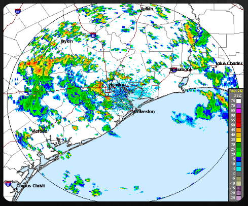
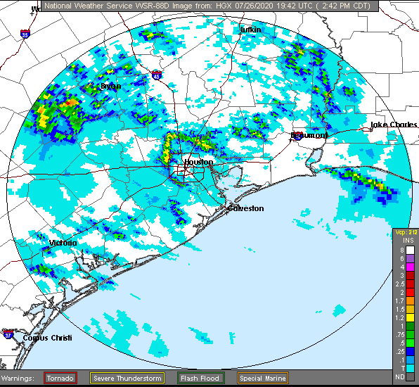
Base Reflectivity (out to 124 nm)
This is a display of echo intensity (reflectivity) measured in dBZ (decibels of Z, where Z represents the energy reflected back to the radar). "Reflectivity" is the amount of transmitted power reflected off an object and returned to the radar receiver. Base Reflectivity images are used to detect precipitation, evaluate storm structure, locate atmospheric boundaries and determine hail potential. -
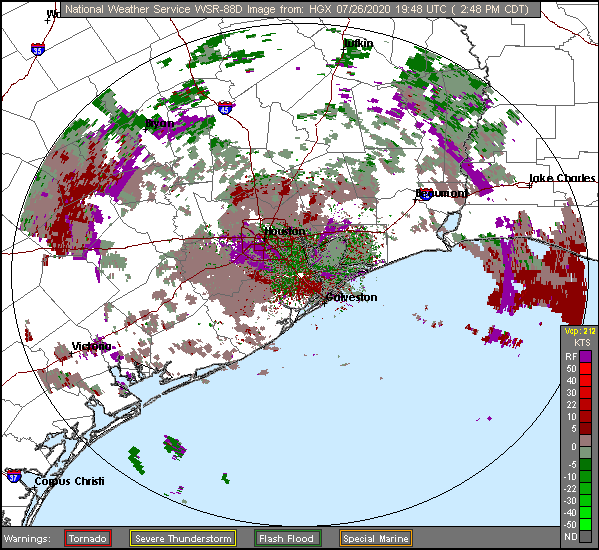
Storm Relative Motion
This display is of radial velocity of the wind relative to the storm's motion. The result is a picture of the wind as if the storms were stationary. This often unmasks storms that rotate (supercells) which can be a precursor to the formation of tornadoes. Green colors indicate wind moving toward the radar with red colors indicating wind moving away from the radar. The maximum range of this product is 124 nm (about 143 miles) from the radar location. -
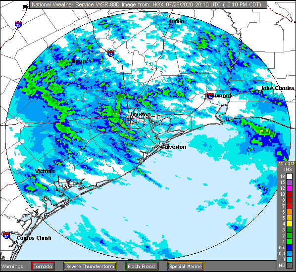
One-Hour Precipitation
This is an image of estimated one-hour precipitation accumulation. This product is used to assess rainfall intensities for flash flood warnings, urban flood statements and special weather statements. The maximum range of this product is 124 nm (about 143 miles) from the radar location. -
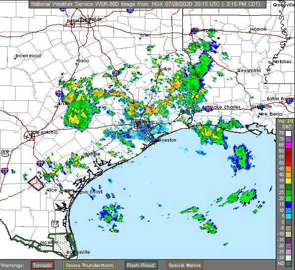
Composite Reflectivity
This display is of maximum echo intensity (reflectivity) from any elevation angle at every range from the radar. This product is used to reveal the highest reflectivity in all echoes. When compared with Base Reflectivity, the Composite Reflectivity can reveal important storm structure features and intensity trends of storms. -
Storm Total Precipitation
This image is of estimated accumulated rainfall, continuously updated, since the last one-hour break in precipitation. This image is used to locate flood potential over urban or rural areas, estimate total basin runoff and provide rainfall accumulations for the duration of the event. The maximum range of this product is 124 nm (about 143 miles) from the radar location. This product will not display accumulated precipitation more distant than 124 nm, even though precipitation may be occurring at greater distances. To determine accumulated precipitation at greater distances link to an adjacent radar. -
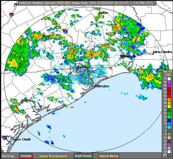
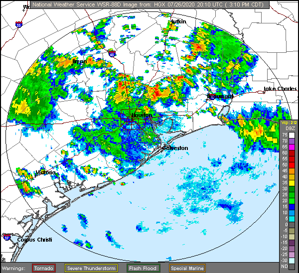
Base Reflectivity (out to 248 nmi)
This is a display of echo intensity (reflectivity) measured in dBZ (decibels of Z, where Z represents the energy reflected back to the radar). "Reflectivity" is the amount of transmitted power reflected off an object and returned to the radar receiver. Base Reflectivity images are used to detect precipitation, evaluate storm structure, locate atmospheric boundaries and determine hail potential.
Regional Radars and Satellite - Northern US
-
**Alaska Loop
https://radar.weather.gov/ridge/Conus/Loop/alaskaLoop.gif -
**Pacific Northwest
https://radar.weather.gov/ridge/Conus/Loop/pacnorthwest_loop.gif
Sattelite Image Loop from GOES16 on NOAA
https://cdn.star.nesdis.noaa.gov/GOES16/ABI/SECTOR/PNW/Sandwich/GOES16-PNW-Sandwich-600x600.gif
Sattelite Image Loop from GOES16 on NOAA Geocolor
https://cdn.star.nesdis.noaa.gov/GOES16/ABI/SECTOR/PNW/GEOCOLOR/GOES16-PNW-GEOCOLOR-600x600.gif -
**Northern Rockies Sector
https://radar.weather.gov/ridge/Conus/Loop/northrockies_loop.gif
Sattelite Image Loop from GOES16 on NOAA
https://cdn.star.nesdis.noaa.gov/GOES16/ABI/SECTOR/NR/Sandwich/GOES16-NR-Sandwich-600x600.gif
Sattelite Image Loop from GOES16 on NOAA Geocolor
https://cdn.star.nesdis.noaa.gov/GOES16/ABI/SECTOR/NR/GEOCOLOR/GOES16-NR-GEOCOLOR-600x600.gif -
**Upper Mississippi Valley Sector
https://radar.weather.gov/ridge/Conus/Loop/uppermissvly_loop.gif
Sattelite Image Loop from GOES16 on NOAA
https://cdn.star.nesdis.noaa.gov/GOES16/ABI/SECTOR/umv/Sandwich/GOES16-UMV-Sandwich-600x600.gif
Sattelite Image Loop from GOES16 on NOAA Geocolor
https://cdn.star.nesdis.noaa.gov/GOES16/ABI/SECTOR/umv/GEOCOLOR/GOES16-UMV-GEOCOLOR-600x600.gif
Weather Underground Regional Radar
https://s.w-x.co/staticmaps/wu/wu/wxtype1200_cur/uslit/animate.png -
**Central Great Lakes Sector
https://radar.weather.gov/ridge/Conus/Loop/centgrtlakes_loop.gif
Sattelite Image Loop from GOES16 on NOAA
https://cdn.star.nesdis.noaa.gov/GOES16/ABI/SECTOR/CGL/Sandwich/GOES16-CGL-Sandwich-600x600.gif
Sattelite Image Loop from GOES16 on NOAA Geocolor
https://cdn.star.nesdis.noaa.gov/GOES16/ABI/SECTOR/CGL/GEOCOLOR/GOES16-CGL-GEOCOLOR-600x600.gif
Weather Underground Regional Radar
https://s.w-x.co/staticmaps/wu/wu/wxtype1200_cur/usspi/animate.png -
**Northeast Sector
https://radar.weather.gov/ridge/Conus/Loop/northeast_loop.gif
Sattelite Image Loop from GOES16 on NOAA
https://cdn.star.nesdis.noaa.gov/GOES16/ABI/SECTOR/NE/Sandwich/GOES16-NE-Sandwich-600x600.gif
Sattelite Image Loop from GOES16 on NOAA Geocolor
https://cdn.star.nesdis.noaa.gov/GOES16/ABI/SECTOR/NE/GEOCOLOR/GOES16-NE-GEOCOLOR-600x600.gif
Regional Radars and Satellite - Southern US
-
**Pacific Southwest Sector
https://radar.weather.gov/ridge/Conus/Loop/pacsouthwest_loop.gif
Sattelite Image Loop from GOES16 on NOAA
https://cdn.star.nesdis.noaa.gov/GOES16/ABI/SECTOR/PSW/Sandwich/GOES16-PSW-Sandwich-600x600.gif
Sattelite Image Loop from GOES16 on NOAA Geocolor
https://cdn.star.nesdis.noaa.gov/GOES16/ABI/SECTOR/PSW/GEOCOLOR/GOES16-PSW-GEOCOLOR-600x600.gif -
**Southern Rockies Sector
https://radar.weather.gov/ridge/Conus/Loop/southrockies_loop.gif
Sattelite Image Loop from GOES16 on NOAA
https://cdn.star.nesdis.noaa.gov/GOES16/ABI/SECTOR/SR/Sandwich/GOES16-SR-Sandwich-600x600.gif
Sattelite Image Loop from GOES16 on NOAA Geocolor
https://cdn.star.nesdis.noaa.gov/GOES16/ABI/SECTOR/SR/GEOCOLOR/GOES16-SR-GEOCOLOR-600x600.gif -
**Southern Plains Sector
https://radar.weather.gov/ridge/Conus/Loop/southplains_loop.gif
Sattelite Image Loop from GOES16 on NOAA
https://cdn.star.nesdis.noaa.gov/GOES16/ABI/SECTOR/SP/Sandwich/GOES16-SP-Sandwich-600x600.gif
Sattelite Image Loop from GOES16 on NOAA Geocolor
https://cdn.star.nesdis.noaa.gov/GOES16/ABI/SECTOR/SP/GEOCOLOR/GOES16-SP-GEOCOLOR-600x600.gif -
**Southern Mississippi Valley Sector
https://radar.weather.gov/ridge/Conus/Loop/southmissvly_loop.gif
Sattelite Image Loop from GOES16 on NOAA
https://cdn.star.nesdis.noaa.gov/GOES16/ABI/SECTOR/SMV/Sandwich/GOES16-SMV-Sandwich-600x600.gif
Sattelite Image Loop from GOES16 on NOAA Geocolor
https://cdn.star.nesdis.noaa.gov/GOES16/ABI/SECTOR/SMV/GEOCOLOR/GOES16-SMV-GEOCOLOR-600x600.gif -
**Southeast Sector
https://radar.weather.gov/ridge/Conus/Loop/southeast_loop.gif
Sattelite Image Loop from GOES16 on NOAA
https://cdn.star.nesdis.noaa.gov/GOES16/ABI/SECTOR/SE/Sandwich/GOES16-SE-Sandwich-600x600.gif
Sattelite Image Loop from GOES16 on NOAA Geocolor
https://cdn.star.nesdis.noaa.gov/GOES16/ABI/SECTOR/SE/GEOCOLOR/GOES16-SE-GEOCOLOR-600x600.gif
National Radar
Hurricane Track Atlantic Satellite
Sattelite Image Loop from GOES16 on NOAA - Atlantic
https://cdn.star.nesdis.noaa.gov/GOES16/ABI/SECTOR/TAW/Sandwich/GOES16-TAW-Sandwich-900x540.gif
Sattelite Image Loop from GOES16 on NOAA Geocolor - Atlantic
https://cdn.star.nesdis.noaa.gov/GOES16/ABI/SECTOR/TAW/GEOCOLOR/GOES16-TAW-GEOCOLOR-900x540.gif
Sattelite Image Loop from GOES16 on NOAA - Gulf of Mexico
https://cdn.star.nesdis.noaa.gov/GOES16/ABI/SECTOR/GM/Sandwich/GOES16-GM-Sandwich-1000x1000.gif
Sattelite Image Loop from GOES16 on NOAA Geocolor - Gulf of Mexico
https://cdn.star.nesdis.noaa.gov/GOES16/ABI/SECTOR/GM/GEOCOLOR/GOES16-GM-GEOCOLOR-1000x1000.gif
Sattelite Image Loop from GOES16 on NOAA - Caribbean
https://cdn.star.nesdis.noaa.gov/GOES16/ABI/SECTOR/CAR/Sandwich/GOES16-CAR-Sandwich-1000x1000.gif
Sattelite Image Loop from GOES16 on NOAA Geocolor - Caribbean
https://cdn.star.nesdis.noaa.gov/GOES16/ABI/SECTOR/CAR/GEOCOLOR/GOES16-CAR-GEOCOLOR-1000x1000.gif
Sattelite Image Loop from GOES16 on NOAA - Eastern Seaboard
https://cdn.star.nesdis.noaa.gov/GOES16/ABI/SECTOR/EUS/Sandwich/GOES16-EUS-Sandwich-1000x1000.gif
Sattelite Image Loop from GOES16 on NOAA Geocolor - Eastern Seaboard
https://cdn.star.nesdis.noaa.gov/GOES16/ABI/SECTOR/EUS/GEOCOLOR/GOES16-EUS-GEOCOLOR-1000x1000.gif
Satellite Image for Canada
Sattelite Image Loop from GOES16 on NOAA - Canada
https://cdn.star.nesdis.noaa.gov/GOES16/ABI/SECTOR/CAN/Sandwich/GOES16-CAN-Sandwich-1125x560.gif
Sattelite Image Loop from GOES16 on NOAA Geocolor - Canada
https://cdn.star.nesdis.noaa.gov/GOES16/ABI/SECTOR/CAN/GEOCOLOR/GOES16-CAN-GEOCOLOR-1125x560.gif
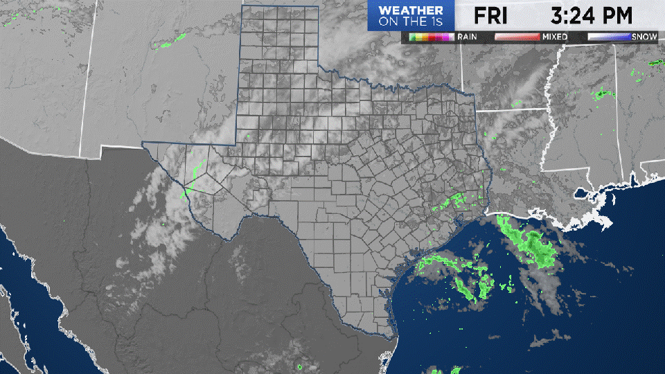
Bonus Map I came across for people in Texas
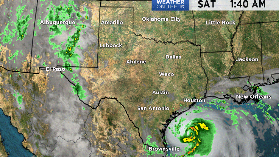
If you come across a great radar loop let me know and I'll add it to the bonus maps.


