PiAware flight tracking

Anyone use this? It's an ADS-B receiver on a raspberry pi that receives transponder information from aircraft that are close. I'm using a cheap Nooelec SDR dongle for the radio. I live right under a flight path, and my kids are always asking (especially with low flying planes) where they are coming in from and how high they are.

Well, now I have an answer for all of this. It's pretty sweet. Also, if you link it to a flightaware account, they will upgrade your account to an enterprise one, which is normally $90/mo.

I want to take the data from PiAware, and when a plane is within 0.3nm, have the ability to turn on TTS alerting that speaks the altitude of the plane and the origin city. I also want a dashboard widget that lists any current planes within 0.5nm and maybe a history of the last 3.

Has anyone played with this?

Here are the instructions for building one. It took me 15 mins while I was sitting on a conference call for work since I already happened to have all of the equipment laying around doing nothing. :slight_smile: PiAware - build your own ADS-B ground station for integration with FlightAware - FlightAware

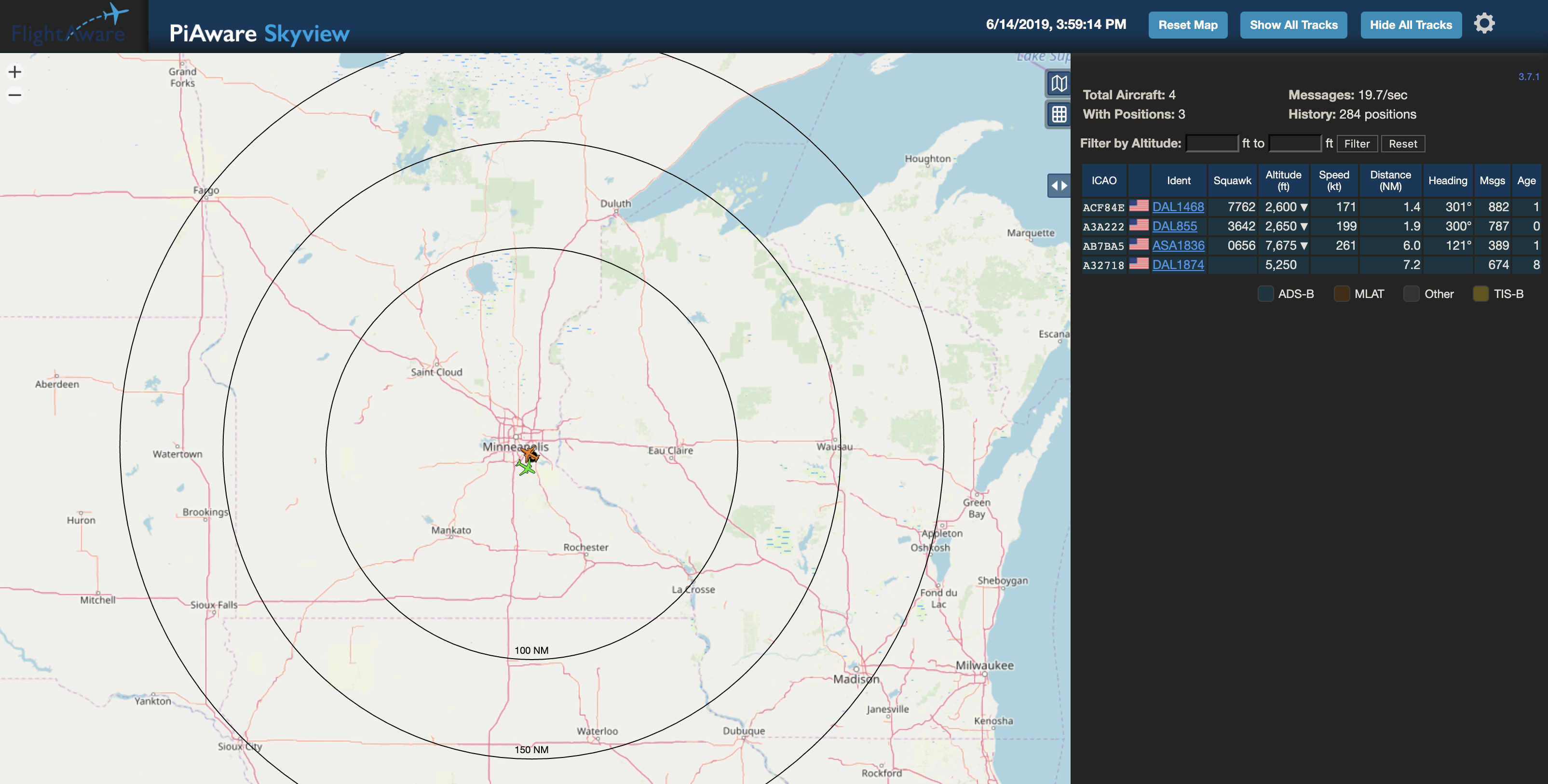
Here's a screenshot. Note that it's only showing stuff really close because the antenna is sitting in a window in my basement (and it's not the ideal length for 1090mhz). If I get the right length antenna and put it outside, it will apparently pick up most planes within 250-400nm.

5 Likes

Very cool! I live right next to MSP so it would go off like crazy for me, but I think it’s a neat idea none the less.

I just ordered a 1090mhz antenna from aliexpress, and another 4 of those RTL-SDR devices (under $7 each).

It will be interesting to see the data on the mosquito spraying helicopter when they come out here to spray the lake, that pilot is insane.

In any case, it appears I can dump the JSON directly from the pi:

Here's an example from mine:
{ "now" : 1560549968.7,
"messages" : 146479,
"aircraft" : [
{"hex":"a94ae3","flight":"UAL1715 ","alt_baro":6075,"alt_geom":5950,"gs":209.7,"track":352.6,"baro_rate":-1088,"squawk":"3642","emergency":"none","category":"A3","nav_qnh":1002.4,"nav_altitude_mcp":4992,"nav_heading":329.8,"lat":44.712021,"lon":-92.926222,"nic":8,"rc":186,"seen_pos":7.2,"version":2,"nic_baro":1,"nac_p":9,"nac_v":1,"sil":3,"sil_type":"perhour","gva":2,"sda":2,"mlat":[],"tisb":[],"messages":81,"seen":4.7,"rssi":-18.4},
{"hex":"ac98c1","flight":"EDV3434 ","alt_baro":2750,"tas":154,"true_heading":293.2,"baro_rate":-768,"squawk":"7450","emergency":"none","category":"A3","nav_qnh":1002.4,"nav_altitude_mcp":3008,"version":2,"nic_baro":1,"nac_p":0,"nac_v":1,"sil":0,"sil_type":"perhour","gva":0,"sda":2,"mlat":[],"tisb":[],"messages":648,"seen":0.2,"rssi":-3.4},
{"hex":"a37616","category":"A3","version":2,"sil_type":"perhour","mlat":[],"tisb":[],"messages":808,"seen":254.1,"rssi":-15.8}
]
}

If all the data you want to bring into HE is available in a json output from the Pi then it is not too difficult to create a virtual device driver to bring the data into HE and therefore could be displayed on a dashboard.

I have to say, I find this interesting and think this would be quite a nice project

Andy

3 Likes

Would I need a driver, or an app? There seems to be no documentation on the difference.

Very cool! I’m interested to learn more about how to set this up as well!

I would use a virtual device driver to get the data from the Pi
Then I personally would use Supertile to display it on a dashboard.
But you could probably format the output from the driver to present on a standard ‘attribute’ tile.
It depends on how much data you wanted to present.
It may need more than one tile.

Andy

This topic remembered me OpenSky, a free flight tracking API that I've used in the past for another project.
I've release a simple Hubitat driver for it: [BETA] OpenSky driver - Flights tracking

This topic was automatically closed 365 days after the last reply. New replies are no longer allowed.